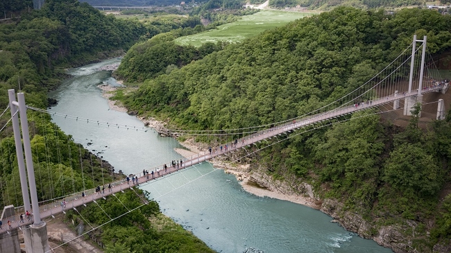
The Main Attraction: Hantangang Sky Bridge (한탄강 하늘다리)
Just a couple of hours from the relentless energy of Seoul lies a landscape forged by fire and time: the Hantangang River Geopark, a UNESCO Global Geopark. At its heart, suspended dramatically over a volcanic canyon, is the Hantangang Sky Bridge (한탄강 하늘다리). This is not merely a bridge; it’s a gateway to understanding the raw geological power that has shaped this part of the Korean peninsula. Opened in 2018, this 200-meter-long suspension bridge hangs 50 meters above the river, offering an exhilarating and slightly swaying passage across the gorge. The experience of walking across is captivating. The grated steel floor allows for a dizzying, direct view of the turquoise river below, while the panoramic vistas of the surrounding cliffs are nothing short of breathtaking.
📍 Curated Route Timeline & Navigation
Hantangang Y-shaped Suspension Bridge
What makes this view so unique are the columnar joints—perfectly geometric, hexagonal rock pillars that line the canyon walls. These are the cooling scars of a massive lava flow from hundreds of thousands of years ago. From the center of the Hantangang Sky Bridge, you get an unparalleled perspective of this natural masterpiece, a sight typically reserved for geologists and adventurous hikers. Below, you can often spot trekkers on the Hantangang Mulwitgil (물윗길), a floating pontoon trail that follows the river’s path, offering a stark contrast in perspective. As you gaze out from the bridge, the sense of scale is immense, and the urban hustle feels a world away. This is a place for quiet contemplation and appreciation of nature’s artistry. The bridge itself is an impressive feat of engineering, designed to provide maximum views with a feeling of secure adventure. It serves as the perfect introduction to the region and is often the highlight for first-time visitors exploring the geopark.
Key Information: Hantangang Sky Bridge
Operating Hours: 09:00 – 18:00 daily (Year-round)
Entrance Fee: Free
Parking: A large, complimentary parking lot is available near the entrance.
Note: The bridge may close temporarily during severe weather conditions such as typhoons or heavy snow.
The accessibility of the Hantangang Sky Bridge makes it a popular starting point for a day of exploration. It connects different segments of the Hantangang Columnar Joint Trail (한탄강 주상절리길), allowing you to easily combine your visit with other nearby natural wonders. Whether you are a seasoned hiker looking to tackle the full trail or a casual visitor seeking a spectacular photo opportunity, the bridge delivers an unforgettable experience. The area is particularly beautiful during the autumn when the surrounding foliage turns into a vibrant tapestry of reds and golds, contrasting sharply with the dark volcanic rock of the canyon.
2026 Ultimate Goseong Lavender Farm Guide: 5 Must-Visit Spots
Exploring the Geopark Trail: Key Stops
The Hantangang Sky Bridge is the anchor of a network of trails and attractions within the geopark. The true magic of the area reveals itself when you venture beyond the bridge and explore the connecting paths. The Hantangang Columnar Joint Trail is a well-maintained trekking course that links several key points of interest, creating a perfect half-day itinerary on foot. The walk itself is as much an attraction as the destinations, winding through serene forests and offering continuous, stunning views of the river canyon. The trail system is clearly marked, making it easy for international visitors to navigate.
A short, scenic walk of about 20 minutes from the bridge will lead you to Bidulginang Waterfall (비둘기낭 폭포), or “Pigeon’s Nest Waterfall.” This is arguably one of the most mystical and beautiful waterfalls in the country. Tucked away in a collapsed lava cave, the waterfall cascades into a brilliant emerald-green pool, surrounded by dramatic columnar joints and lush vegetation. The unique, enclosed shape of the gorge creates a serene and almost otherworldly atmosphere. Its cinematic quality has not gone unnoticed; it has served as a filming location for numerous K-dramas, including Netflix’s Kingdom and Arthdal Chronicles. A wooden staircase leads you down to a viewing platform, allowing for an up-close experience with the falls.
Continuing along the trail for another 10-15 minutes, you will arrive at the newer and architecturally striking Hantangang Y-shaped Suspension Bridge (한탄강 Y자 출렁다리). As its name suggests, this bridge features a unique three-way design, allowing you to walk out to a central point and gaze down two different arms of the canyon. This provides a different, but equally thrilling, perspective compared to the straight path of the Hantangang Sky Bridge. This entire trekking route, from the Y-shaped bridge to the waterfall and finally to the main sky bridge, forms a cohesive and highly rewarding journey through the park’s geological highlights. Each stop offers a new angle on the magnificent lava-carved landscape, making the entire trail a continuous discovery. The full course is a testament to the area’s successful blend of natural preservation and accessible tourism.
| Hotspot Name | Category | Key Activity | Nearest Transit Hub | Cost |
|---|---|---|---|---|
| Hantangang Sky Bridge | Suspension Bridge | Canyon viewing, Photography | Pocheon Intercity Bus Terminal | Free |
| Bidulginang Waterfall | Natural Landmark | Waterfall viewing, K-drama spot | Pocheon Intercity Bus Terminal | Free |
| Hantangang Y-shaped Bridge | Suspension Bridge | Trekking, Unique gorge views | Pocheon Intercity Bus Terminal | Free |
Gyeongju Peony Flowers: 2026 Guide to 2 Best Spots
💡 Practical Insider Tips & Itinerary
Visiting the Hantangang Geopark is a fantastic day trip, but its semi-rural location requires some planning to ensure a smooth experience. As a local guide, I’ve compiled the most essential tips to help you navigate the area like a pro. From transportation to timing, these details will make your visit to the Hantangang Sky Bridge and its surroundings seamless and memorable. The region is well-equipped for local tourists but can present minor challenges for international visitors, so preparation is key.
- Navigation is Key: First and foremost, Google Maps does not provide reliable walking or transit directions in South Korea due to security regulations. Before you go, you must download a Korean navigation app. KakaoMap and Naver Map are the standard and both offer excellent English interfaces. Use them for real-time bus schedules, walking routes between the attractions, and finding nearby cafes or restaurants.
- Getting There from Seoul: The most practical way to reach the park is by car (about 1.5-2 hours). If using public transport, take an intercity bus from Dong Seoul Bus Terminal (동서울종합터미널) to Pocheon Intercity Bus Terminal (포천시외버스터미널). From there, you will need to take a local bus or a taxi to the Geopark entrance. Taxis are the most convenient option and will cost approximately 15,000 – 20,000 KRW (~$11-15 USD).
- What to Wear & Pack: Comfortable, sturdy walking shoes are non-negotiable. The trails are well-maintained but involve stairs and uneven surfaces. Dress in layers, as the temperature in the canyon can be cooler than expected. Pack water and snacks, as options are limited once you are on the main trails. Luggage storage is not available on-site, so travel light for the day.
- Best Time to Visit: To avoid the largest crowds, plan your visit for a weekday morning. The park is especially popular on weekends and public holidays. The best seasons are spring (April-May) and autumn (October-November) for pleasant weather and beautiful natural colors.
- Facilities and Payments: All main attractions, including the Hantangang Sky Bridge, are free of charge. There are public restrooms near the main parking lots. While larger restaurants in the area accept credit cards, it’s always wise to carry some Korean Won (KRW) in cash for smaller vendors or local buses.
Sample One-Day Itinerary:
To experience the best of the park logically, I recommend following the trail from north to south. This route provides a beautiful narrative, saving the grandest view for last.
- 10:30 AM – Arrive & Start at the Y-shaped Bridge: Take a taxi to the entrance nearest the Hantangang Y-shaped Suspension Bridge. Start your day with this unique structure.
- 11:30 AM – Walk to Bidulginang Waterfall: Follow the well-marked Columnar Joint Trail. The walk is about 10-15 minutes and is incredibly scenic. Spend time at the viewing deck admiring the falls.
- 12:30 PM – Lunch: Head back towards the main road near the waterfall entrance. You’ll find a few local Korean restaurants (식당) specializing in dishes like maeun-tang (spicy fish stew) or dak-bokkeum-tang (spicy braised chicken).
- 2:00 PM – The Grand Finale at Hantangang Sky Bridge: From the waterfall, it’s a pleasant 20-minute walk to the main event, the Hantangang Sky Bridge. Take your time crossing it, soaking in the panoramic views that you’ve earned with your hike.
- 3:30 PM – Depart: The main parking lot for the sky bridge is the easiest place to call a Kakao T taxi for your return journey to the Pocheon bus terminal.
Looking for more local travel tips? Be sure to explore our homepage and browse our latest K-Travel Guide articles for the ultimate South Korea itineraries!